(By courtesy of the Plantijn-Moretus Museum of Antwerp, where the original is displayed)
Abraham Ortelius (April 14, 1527 - June 28, 1598) was a cartographer and geographer, generally recognized as the creator of the first modern atlas. He was born in Antwerp in what is now Belgium.
A member of the influential Ortelius family of Augsburg, he traveled extensively in Europe. He is specifically known to have traveled throughout the Seventeen Provinces; south and west Germany (e.g., 1560, 1575–1576); France (1559-1560); England and Ireland (1576), and Italy (1578, and perhaps twice or thrice between 1550 and 1558).
Beginning as a map-engraver, in 1547 he entered the Antwerp guild of St Luke as afsetter van Karten. His early career is a businessman and most of his journeys before 1560 are for commercial purposes (such as his yearly visits to the Frankfurt book and print fair).
In 1560, however, when travelling with Mercator to Trier, Lorraine and Poitiers, he seems to have been attracted, largely by Mercator’s influence, towards the career of a scientific geographer; in particular he now devoted himself, at his friend’s suggestion, to the compilation of that atlas or Theatrum Orbis Terrarum (Theatre of the World), by which he became famous.
In 1564 he completed a "mappemonde", eight-leaved map of the world, which afterwards appeared in reduced form in the Theatrum. The only extant copy of this great map is in the library of the University of Basle (cf. Bernoulli, Ein Karteninkunabelnband, Basle, 1905, p. 5). He also published a two-sheet map of Egypt in 1565, a plan of Brittenburg Castle on the coast of the Netherlands in 1568, an eight-sheet map of Asia in 1567, and a six-sheet map of Spain before the appearance of his atlas.
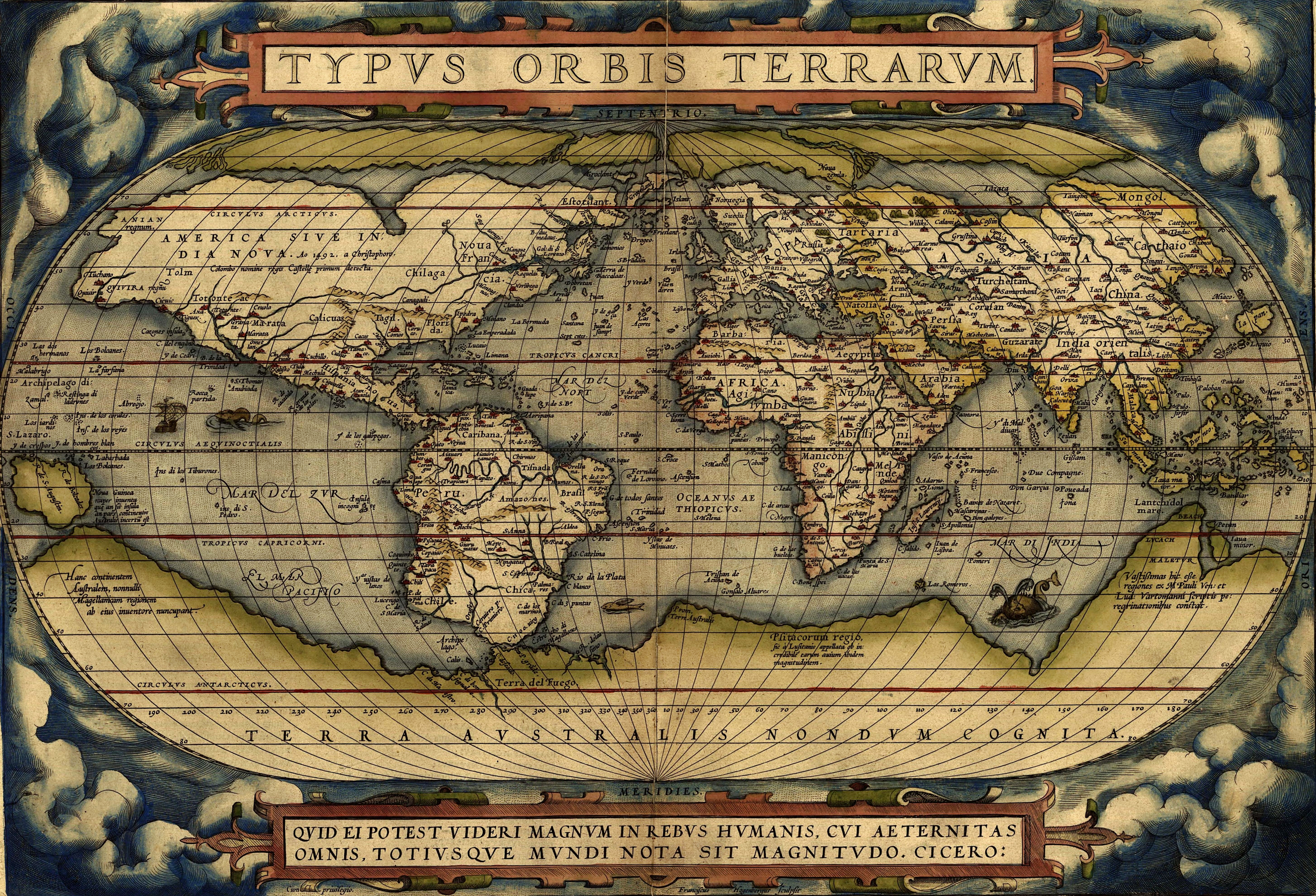
Ortelius World Map
In 1570 (May 20) was issued, by Gilles Coppens de Diest at Antwerp, Ortelius’ Theatrum Orbis Terrarum, the "first modern atlas" (of 53 maps). Three Latin editions of this (besides a Dutch, a French and a German edition) appeared before the end of 1572; twenty-five editions came out before Ortelius' death in 1598; and several others were published subsequently, for the atlas continued to be in demand till about 1612. Most of the maps were admittedly reproductions (a list of 87 authors is given in the first Theatrum by Ortelius himself, growing to 183 names in the 1601 Latin edition), and many discrepancies of delineation or nomenclature occur. Errors, of course, abound, both in general conceptions and in detail; thus South America is initially very faulty in outline, but corrected in the 1587 French edition, and in Scotland the Grampians lie between the Forth and the Clyde; but, taken as a whole, this atlas with its accompanying text was a monument of rare erudition and industry. Its immediate precursor and prototype was a collection of thirty-eight maps of European lands, and of Asia, Africa, Tartary and Egypt, gathered together by the wealth and enterprise, and through the agents, of Ortelius’ friend and patron, Gilles Hooftman, lord of Cleydael and Aertselaer: most of these were printed in Rome, eight or nine only in Belgium.
References
- Pallas & Janos international maps and prints ., "Maps and prints (Abraham Ortelius)".
http://www.pallasjanos.com/uk/orteliusuk.html
thank you for sharing
ตอบลบviagra jakarta
viagra asli
viagra usa
jual viagra
viagra original usa jakarta
obat viagra
viagra obat kuat
viagra asli jakarta
toko viagra jakarta