12/31/2553

The Magnetic Compass ☺

Background Information


- Compass is an instrument containing a freely suspended magnetic element which displays the direction of the horizontal component of the Earth's magnetic field at the point of observation.


 Magnetic Compass is an old Chinese invention, probably first made in China during the Qing dynasty (221 -1206 B.C.). Chinese fortune tellers used lodestones (a mineral composed of an iron oxide which aligns itself in a north-south direction)  to construct their fortune telling boards.


Where was the compass first used?


- The origin of the compass is shrouded in mystery. Certainly the Greeks knew about the attractive properties of magnetism in ancient times. Similarly, the Chinese were probably aware that an iron bar stroked with a lodestone acquired a directional north-south property as long as 2000 years ago. However, the precise date at which this knowledge was used to create the first magnetic compass is unknown. By the 10th century, the idea had been brought to Europe, probably from China, by Arab traders. Magnetic compasses of a very simple kind were certainly in use in the Mediterranean as early as the 12th century. However, early compasses were not very reliable. Although the magnetic compass was in general use in the Middle Ages, little was known about precisely how it worked.

How does a magnetic compass work?


- A magnetic compass works because the Earth is like a giant magnet, surrounded by a huge magnetic field. The Earth has two magnetic poles which lie near the North and South poles. The magnetic field of the Earth causes a magnetized 'needle' of iron or steel to swing into a north-south position if it is hung from a thread, or if it is stuck through a straw or piece of wood floating in a bowl of water.

How were needles magnetized?


Needles were magnetized by stroking them with a lodestone, a lump of magnetic rock called magnetite. The needle did not keep its magnetism permanently, so a lodestone was carried on the ship so that the needle could be stroked whenever the magnetism wore off.

How accurate is the magnetic compass?


- As long ago as the 15th century, mariners noticed that the needle of a magnetic compass does not point accurately to Earth's true north. Columbus, for instance was aware of this on his voyages across the Atlantic in the 1490s. Instead, the needle makes an angle with true north, and that angle varies from place to place on the Earth's surface. This means that there is a different magnetic variation for different places on Earth. These variations were investigated on a famous 17th century voyage by the great scientist and astronomer Edmond Halley. It was thought at this time that the longitude of a ship could be found by the compass variation, but this proved to be untrue.

How were the simplest compasses improved?


A great improvement came when the needle was mounted under a card on a sharp pin, and placed in a little turned wooden or ivory box.

How were these cards marked out?


- At first, compass cards were marked out not in degrees, but in points. There were 32 points, matching the directions of winds which sailors would be familiar with at sea. The four main points – North, South, East and West – are called the cardinal points.

Old compass cards are very ornamental, often covered with decoration and painted figures. All cards have the North point decorated with what is often called a fleur de lys, like the old royal symbol of France. In fact, the sign comes from a very decorated 'T' for Tramontana, the Latin word for the North wind.

There is a lot of movement on board a ship at sea. What happens to the compass then?


- To stop the needle and card from swinging wildly on board ship, even early compasses were gimbal mounted in a square box by an attachment with swivelling rings. This means that the compass is hung in a way that makes it unaffected by the movement of the ship on the sea. The remains of one such compass, housed in a special stand called a binnacle, was found in the wreck of King Henry VIII's flagship, the Mary Rose, which sank in 1546. At that time, the compass would have been lit at night by a candle.

By the 19th century, the ships compass had become the familiar large, gimbal mounted instrument, enclosed in a binnacle with its own light.

Do iron ships pose particular problems for magnetic compasses?


- Yes. The magnetic field of the iron body of the ship itself affects the reading on the compass.
When iron and steel ships became common, many scientists studied the problem. One of the earliest was the Astronomer Royal, Sir G.B. Airy, who in 1838 used the iron steamer Rainbow for his experiments. Airy thought of a method of neutralizing a ship's magnetism by placing magnets and pieces of unmagnetized iron near the compass.

References


- "THE MAGNETIC COMPASS - HISTORY"., http://www.solarnavigator.net/compass.htm

Volcanoes in Thailand ⊙▂⊙

Background information

Volcanoes are classified in to five groups based on the shape of the volcano, the materials they are built of and the way the volcano erupts. 

1. Composite Volcanoes (Strato Volcanoes) are formed by alternating layers of lava and rock fragments.  This is the reason they are called "composite". They usually erupt in an explosive way.  This is usually caused by viscous magma.


2. Shield Volcanoes (Shields) are huge in size.  They are built by many layers of runny lava flows. It may be produced by hot spots which lay far away from the edges of tectonic plates.The eruptions of shield volcanoes are characterized by low-explosivity lava-fountaining that forms cinder cones and spatter cones at the vent 


3. Cinder Cones is a steep conical hill formed above a vent. They are among the most common volcanic landforms found in the world.hey aren't famous as their eruptions usually don't cause any loss of life. They are chiefly formed by Strombolian eruptions.The cones usually grow up in groups and they often occur on the flanks of strato volcanoes and shield volcanoes.


4. Spatter Cones 
          When hot erupting lava contains just enough explosive gas to prevent the formation of a lava flow, but not enough to shatter it into small fragments the lava is torn by expanding gases into fluid hot clots, ranging in size from 1cm to 50cm across, called "spatter".
          When the spatter falls back to Earth the clots weld themselves together and solidify forming steep-sided accumulations. These accumulations focused on an individual vent are called "spatter cones".


5. Complex Volcanoes
          In fact all volcanoes could be complex volcanoes since all of them are made up of multiple flows, ash layers, domes, cones, etc. in varying amounts.
          However, when we call a volcano a complex volcano it is because we mean the "system" of those volcanoes is not "simple".  Caldera complexes for instance have often got a large caldera with many subsidiary vents and deposits, some of which could be considered "volcanoes" in their own right.


          In Thailand, there are so many volcanoes all around the regions. Almost all of them are Shield volcanoes, which the eruptions of shield volcanoes are characterized by low-explosivity lava-fountaining. However, all of them are "extinct volcanoes".
          
          Extinct volcanoes are those that scientists consider unlikely to erupt again, because the volcano no longer has a lava supply.

Volcanoes in Thailand are found :
Northern (city) : Lampang, Chiang Rai, Phrae, Nan, Uttaradit
Central (city) : Sukhothai, Kamphaeng Phet, Phetchabun, Saraburi, Lop Buri
East (city) : Chanthaburi, Prachin Buri, Nakhon Nayok, Trat
West (city) : Kanchanaburi, Tak
Northeast (city) : Nakhon Si Thammarat, Si Sa Ket, Ubon Ratchathani, Buri Ram, Loei, Surin


          The oldest volcano of Thailand is in Loei (city). The volcano is around 395-435 million years.


References


- ORACLE ThinkQuest., "types of volcanoes".
http://library.thinkquest.org


12/30/2553

Abraham Ortelius ✎

Abraham Ortelius as depicted by Paul Rubens (1577-1640). 
(By courtesy of the Plantijn-Moretus Museum of Antwerp, where the original is displayed)

Abraham Ortelius (April 14, 1527 - June 28, 1598) was a cartographer and geographer, generally recognized as the creator of the first modern atlas. He was born in Antwerp in what is now Belgium. 


          A member of the influential Ortelius family of Augsburg, he traveled extensively in Europe. He is specifically known to have traveled throughout the Seventeen Provinces; south and west Germany (e.g., 1560, 1575–1576); France (1559-1560); England and Ireland (1576), and Italy (1578, and perhaps twice or thrice between 1550 and 1558). 


          Beginning as a map-engraver, in 1547 he entered the Antwerp guild of St Luke as afsetter van Karten. His early career is a businessman and most of his journeys before 1560 are for commercial purposes (such as his yearly visits to the Frankfurt book and print fair). 

         In 1560, however, when travelling with Mercator to Trier, Lorraine and Poitiers, he seems to have been attracted, largely by Mercator’s influence, towards the career of a scientific geographer; in particular he now devoted himself, at his friend’s suggestion, to the compilation of that atlas or Theatrum Orbis Terrarum (Theatre of the World), by which he became famous. 

        In 1564 he completed a "mappemonde", eight-leaved map of the world, which afterwards appeared in reduced form in the Theatrum. The only extant copy of this great map is in the library of the University of Basle (cf. Bernoulli, Ein Karteninkunabelnband, Basle, 1905, p. 5). He also published a two-sheet map of Egypt in 1565, a plan of Brittenburg Castle on the coast of the Netherlands in 1568, an eight-sheet map of Asia in 1567, and a six-sheet map of Spain before the appearance of his atlas. 


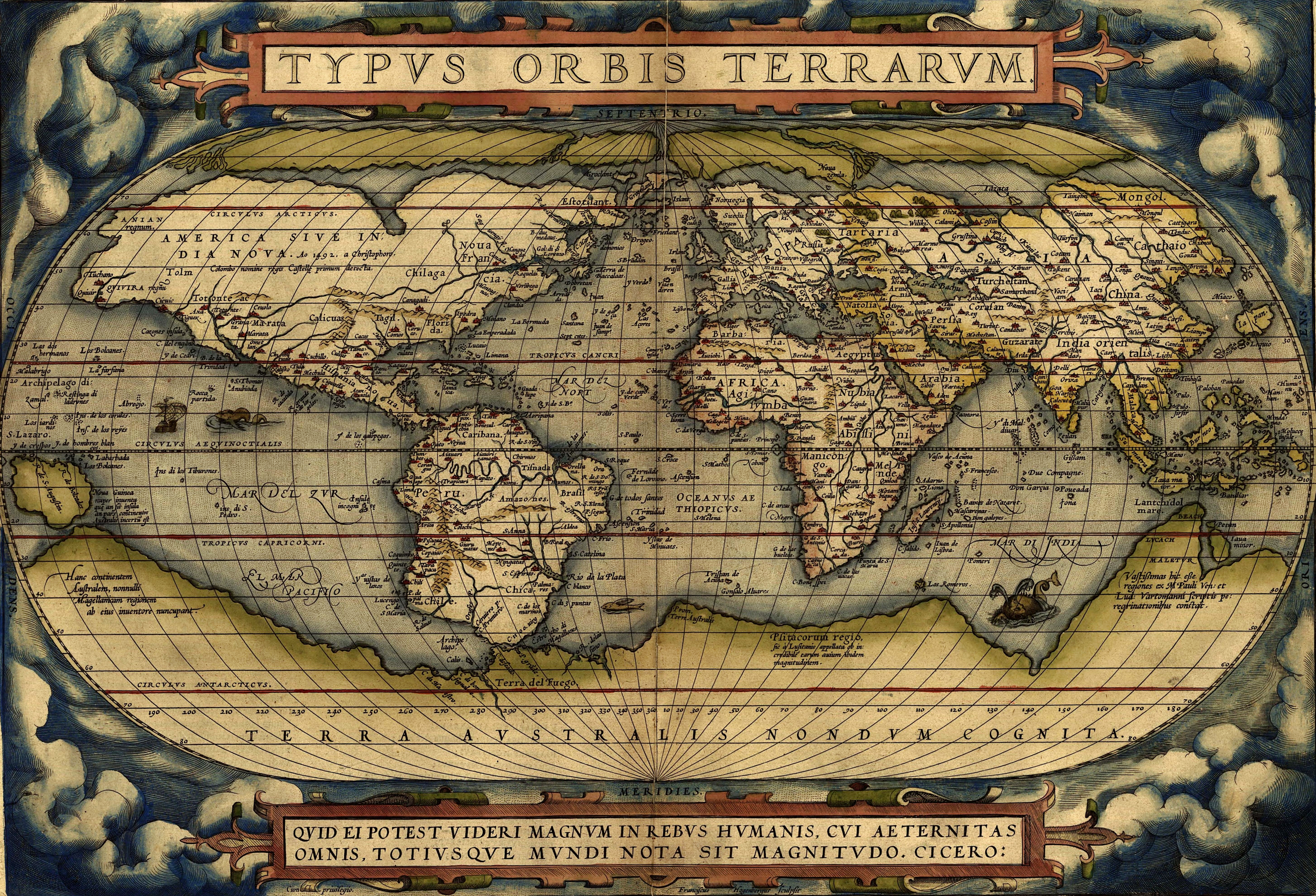
Ortelius World Map

          In 1570 (May 20) was issued, by Gilles Coppens de Diest at Antwerp, Ortelius’ Theatrum Orbis Terrarum, the "first modern atlas" (of 53 maps). Three Latin editions of this (besides a Dutch, a French and a German edition) appeared before the end of 1572; twenty-five editions came out before Ortelius' death in 1598; and several others were published subsequently, for the atlas continued to be in demand till about 1612. Most of the maps were admittedly reproductions (a list of 87 authors is given in the first Theatrum by Ortelius himself, growing to 183 names in the 1601 Latin edition), and many discrepancies of delineation or nomenclature occur. Errors, of course, abound, both in general conceptions and in detail; thus South America is initially very faulty in outline, but corrected in the 1587 French edition, and in Scotland the Grampians lie between the Forth and the Clyde; but, taken as a whole, this atlas with its accompanying text was a monument of rare erudition and industry. Its immediate precursor and prototype was a collection of thirty-eight maps of European lands, and of Asia, Africa, Tartary and Egypt, gathered together by the wealth and enterprise, and through the agents, of Ortelius’ friend and patron, Gilles Hooftman, lord of Cleydael and Aertselaer: most of these were printed in Rome, eight or nine only in Belgium.


References

- Pallas & Janos international maps and prints ., "Maps and prints (Abraham Ortelius)".
http://www.pallasjanos.com/uk/orteliusuk.html

Air pollution in Chiang Mai (Thailand) ☼

The level of air pollution in Chiang Mai increasing

many residents in Chiang Mai have been affected by respiratory infections and 
other health problem,due to the air pollution.

Background information
          Chiang Mai (เชียงใหม่) is the largest and most culturally significant province in northern of Thailand. It is located 700 km. north from Bangkok (the capital city).

Thailand Map


Climate 
          Thailand  has a tropical wet and dry climate. There are three seasons in the country which are  summer (around March - May), rainy (June - September), winter (October - February) .


Air pollution in Chiang Mai
          In the period between March - the beginning of April , a continuing environmental problem facing Chiang Mai is the incidence of air pollution yearly. The city is often shrouded in smoke during this period leading up to the rainy season. The most terrible period air pollution in Chiang Mai was in 2009 which so many northern people were affected by smoke from burning-off undergrowth. The standard acceptable level of dust id 120 milligrams per cubic meter, while the particulate dust levels in the city have tested between 190 micrograms and 243 micrograms per cubic meter sometimes. There are some minor sources of particulate matter pollution is the prevalence of burning in the city, with cremations, burning garbage and vehicular emissions from poorly maintained diesel cars contributing. These minor causes is dust raised during building and excavations. 

The Majority Cause
          The main cause of air pollution in Chiang Mai is the age-old practice of burning-off undergrowth in forests in the mountainous regions, especially along the Thai-Myanmar border. This problem is exacerbated by the location of the city which is located in a natural geographic bowl surrounded by mountains. For several years, as Chiang Mai's air quality index has become more and more troublesome, in relation to the rest of the region, the recognition of the problem has been growing locally. Doctors in Chiang Mai have been noticing an increase in people coming to see them with upper respiratory difficulties. Chiang Mai has now enacted stringent regulation of emissions standards for all vehicles. Since 2008, police sometimes set up roadblocks to test exhaust emissions on the spot and officers will enact the law to ban offending vehicles as Chiang Mai continues to work actively towards a cleaner environment.


References


- Wikipedia, the free encyclopedia., "Chiang Mai".
http://en.wikipedia.org/wiki/Chiang_Mai

11/25/2553

Amazing Natural Phenomenon : Aurora☺

Glitter Words


What is Aurora ?
          Aurora is a naturally light display on the sky in the Arctic and Antarctic circles. The Arctic aurora is often called either the "Northern Lights" or "Aurora Borealis".


How does Aurora happen ?
           These phenomenon causes by the collision of charged particles directed by the Earth's magnetic field, are commonly visible between 65 and 72 degrees north and south latitudes. It do occur deeper in side the polar regions. However the Aurora is infrequent and often invisible to the naked eye.

The 10 most Beautiful Aurora Borealis


The video of Aurora from Youtube